 So, at 6:45 am Anna Z. and I left Seattle in drizzle, and post stop at the Danish Bakery, were at the Vesper Peak trailhead without incident at about 8:45. Why Vesper? So, let me admit one thing. I would say that I am good at finding my way around cities, even entirely unfamiliar ones. I am reasonably proud of my skills in this regard. However, put me on a mountain and I have all the routefinding skills of a developmentally disabled walrus that was liquored, drugged, and then spun around five times. I didn't mention this in the scramble participation solicitation postification because I was hoping for a response from someone wanting to come. Sadly, no one did, although after giving my number, I did get a voicemail of someone breathing heavily for about a minute (climbing club or not? I'll never know). So, I figured, go to something that was almost all on trail, which the Seattle Times called a hike, which had a TR from this month on the climbing club forum, and which actually has a topo available online. Not even I'd screw this up. Reasonable?
Anyway, we started on the trail shortly before 9 in completely blue sky, crossed the creeks at the beginning without incident (stepping stones were no problem), threaded our way up the meadowy switchbacks to the basin of scree below and ascender's right of Headlee pass. Here one of us (AK) suddenly decided to turn right and head up scree, whereas another one of us (AZ) may have even seen the cairns pointing the correct way (straight), but was unaware that this was their function, since this technology is apparently not used in Quebec. So, anyway, we started climbing the reddish scree pile (which we later realised to be) ascender's right of Headlee Pass. Our progress was slow because the scree was steep, and also because we frequently stopped to weigh the relative merits of two truisms: that time already spent on a mistake should be considered sunk cost, but on the other hand that people are much more likely to secondguess themselves incorrectly than correctly (this dilemma is probably familiar to any of you who have ever made mistakes in your life!) Then we climbed some more scree. Then we crossed a small snow-slope. Then we had some scrambly moves, which were nothing too bad, but a little sketchy considering that at this point we were pretty sure this route wasn't leading to the pass. So, finally, the sunk costs truism won, and we turned around. I had my first ever very short unplanned glissade into rocks (not very fun), we slowly redescended the scree and found the obviously marked trail we somehow initially departed. By this point it was 12:30, we were pretty damn tired, and Anna needed to get back into Seattle by 7 to purchase a textbook. We lunched in a shady spot right under the switchbacks up to Headlee Pass, two gullies ascender's left of where we had wasted all that time. We then decided to continue on at least to the pass.
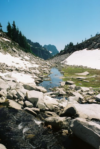
The pass reached, we still figured we had time, followed a well-cairned trail up to and along a very clear, cold and refreshing stream all the way to where two tents were perched above a very, very icy lake. We began to climb the grippy and friendly talus to our left that led up to Vesper. The snow was slow going, so we stayed on rock. It was very enjoyable scrambling, however, we veered far too much to ascender's right and ended up looking at the edge of Vesper's north slope, which is very steep and featureless and thus scary, and so our scramble was much more exposed than it needed to be (clarification: we didn't actually scramble up the north slope or anything... that'd be crazy! We just were too close to it for comfort). We reached the summit at about 2:40 (after several false hopes). South/Seattle direction had some low clouds but everywhere else was clear and blue and beautiful. We marveled, drank water, played super-rookie name-that-peak (Baker, Pugh, Shuksan, Glacier, hey, I wonder if that's Vancouver Island?), and realised there was actually a much less scrambly path to the top on ascender's extreme left of where we went up.
We began to descend this path, tried our hands (asses?) at glissading, but there weren't enough contiguous snow patches for this to be a reasonable method of descent and so continued on rock. At some point Anna and I ended up on opposite ends of a stream that lost itself under a narrow snowslope. I was actually on the ridge-like thing that goes to where the tents were, and Anna was to descender's left of that. Unfortunately the only obvious way to get to where I was from where Anna was was to climb up a bunch and then climb down a bunch. Fearing that we'd get lost if separated, I instead went towards where she was, very uncomfortably, because the stream made all the rock wet and disgusting.
At this point the mosquitoes redoubled their already impressive attacks. I actually saw five sitting simultaneously on one of my forearms, and thanking my lucky stars that I was not a Jain, attempted to slap them with my face (hands being occupied at holding rock). We continued to descend slowly, now on loose, wet, earth+scree combo on the wrong side of a steep snow slope. By wrong, I mean the one that led into the icy lake rather than to the tents and our descent. Seeing that this could not continue indefinitely we traversed the narrow snow slope, were forced to make several climbing moves that I would put into "not difficult but way too freakin' scary" class, and were back to the good. This, as all scary things do, played out in slow motion, naturally, so by the time we were back at the tents, it was past 5. A short dip in the stream and an hour and a half of descent later, we were back at the trailhead, and the only thing that materially suffered was Anna's ability to buy her textbook. Since I don't need the textbook, I judged this to be a totally worthwhile sacrifice for beautiful views and a fun (mixed type 1 and 2) day.